Friday, October 15, 2010

The Yellow Buckeye

Along with the sycamore and green ash, the yellow buckeye Aeseulus octandra is one of the most commonly encountered trees in the bottomlands and riparian corridors of the Captina watershed. Extreme eastern Ohio and the northern panhandle of West Virginia represent the northern-most extent of this species range. Not to be confused with the more popular Ohio buckeye Aesculus glabra of central and western Ohio, the yellow buckeye has a larger nut, a smooth outer husk and in general is taller canopy tree. Yellow buckeyes are usually the first trees to sprout leaves in early spring and the first to lose them in fall.   
*Note:  Buckeye nuts have been known to be slightly poisonous becuse of elevated levels of tannic acid and should not be consumed by humans so keep them out of your mouth and around your neck on gameday ; )


Despite the late summer drought conditions have been great for
a bumper crop of yellow buckeyes.  Certain areas can have several
dozen nuts under one tree.  The nuts can be as large as 2 inches
in diameter but tend to shrink as they dry when broken out of their
husks

Yellow buckeye trees next to Captina Creek.  Note the branches
that are bent toward the ground and the fact these trees
have no leaves left even when others in the forest have yet to
change color.

Yellow buckeye husks are smooth on the outside and can contain
up to five nuts.  The entire structure can be as large as an orange
while ripening in the tree before falling to the ground.

Thursday, October 14, 2010

Fall arrives at Captina Creek

The overall dry weather of the past couple of months combined with decreasing photoperiod and nightly temperature has brought about a colorful change in the watershed's deciduous forests.  Temperatures the past couple of nights have dipped into the low 40's and upper 30's and the sun is now setting at 6:45 pm.  These abiotic environmental factors signal the trees to stop chlorophyll (green in color) production so eventually the pigment breaks down allowing lesser concentrated pigments in the leaf (anthocyanins and carotenoids) to become visible that were originally hidden by chlorophyll over the past growing season.  With chlorophyll production halted leaves are shed by trees to conserve water over the cold winter months.  Leaf colors are peaking along the watershed this week.  The best way to enjoy the colors is to take a drive along S.R. 148 from Barnesville to Powhatan Point.
A section of forest along S.R. 148 west of Alledonia.  Orange and
yellow colors are caused by carotentoid  pigments while reds are
caused by anthocyanins.  Maples, tulip poplars and ashes are usually
the first trees to turn followed by oaks and hickories.  In this photo most
of the oaks still have green foliage. 

One of the best lookouts to observe the forests of the watershed.
Looking northward from the intersection of twp. roads 101 and 121 in
Washington Township just south of Armstrongs Mills.  Enjoy the colors
while you can - they don't last long!


Wednesday, October 13, 2010

More Info on Shadyside Biomass Plant

Good morning.  I thought I would pass along a link providing some additional information regarding the conversion of the Burger power plant from coal consumption to biomass.  The information is from a Pittsburgh, PA perspective which is only 80 miles northeast of the watershed.Click here for more details.

Monday, October 11, 2010

First Energy Biomass Plant Planned for Production

First Energy Corp., who owns the Burger power plant at Dilles Bottom south of Shadyside Ohio, is planning to convert from a coal burning facility to biomass burning facility within two years.  Biomass fuel consists of plant material like trees and grasses which can be harvested on a mass scale then burned to produce electricity.  Sounds like a good alternative to coal until you dig a little deeper and work some simple math to figure out just how much biomass is needed on a daily basis to sustain normal energy outputs - in Burger's case 3,000 tons of trees!!!  With nearly 70% of the Captina Creek watershed secondary forest growth coverage and right downstream from the facility, it's understanding why people would be a bit on edge toward this proposal.  Below is a news release from Cheryl Johncox regarding biomass burning for energy production:


  Some Ohio Power Companies Seeking “Green” Credits For Burning Trees


       Several of Ohio’s coal-fired power plants have announced plans to burn chipped and pelleted trees as a means of generating electricity. The utility companies behind the plans hope to receive renewable energy credits or “RECs” for burning wood fuel as “renewable biomass.” If certified by the Public Utilities Commission of Ohio or “PUCO,” companies can use biomass RECs to meet the renewable energy requirements mandated under Ohio law – requirements that could otherwise be met through truly “clean” and “green” renewable options such as wind and solar. The PUCO has already granted renewable energy certification to 7 power plants that will use wood as their fuel of choice including First Energy's Burger plant in Shadyside. Three other power plants are currently awaiting PUCO approval.

       Unfortunately, trees would have to be cut on an enormous scale to fuel these power plants, which when combined total as much as 2,100 Mega-Watts or “MW” of potential biomass-to-energy generation. Approximately 25,000,000 green tons of wood would have to be cut and extracted every year if that many MWs were to be powered by woody biomass incineration. This figure is grossly unsustainable: woody biomass energy on such a scale would devour three times Ohio’s annual forest growth if trees for fuel are cut within the state. Put somewhat differently, this much woody biomass incineration could clearcut all Ohio forests in a relatively short period of time.


       Moreover, burning trees for electricity generates more CO2 than coal. Carbon dioxide emissions from biomass are about 1.5 times higher than from coal and three to four times higher than from natural gas. Despite this fact, industry groups are currently asking EPA to designate woody biomass as “carbon neutral” under the faulty logic that carbon released from burning trees will ultimately be stored as forests regrow. The simple truth is that carbon is released instantly when wood is burned, and that it takes several decades for “replacement” trees to regrow. Any carbon stored from forest regrowth would be overwhelmed by the much more rapid burning of trees for energy by utility companies.


       Forests in Ohio provide us with many benefits. They provide places to take our families hiking, biking, and camping, and they provide air and water purification, temperature regulation, soil retention, and habitat for wildlife. Exploiting our forests for biomass energy threatens all of these benefits that forests provide.
        The state of Ohio should be focusing on truly renewable energy like wind and solar, supporting energy efficiency measures and investment in developing technologies for local energy generation and storage to reach our targets. Many Ohioans could benefit from reducing their electric bills by monitoring and conserving home usage. Also, many more jobs will be created if utility companies are not given an easy out that will neither reduce greenhouse gases or reduce air pollution.

Cheryl Johncox is Interim Executive Director of Buckeye Forest Council. To connect on this issue, visit Buckeye Forest Council’s website at www.buckeyeforestcouncil.org. You can also follow BFC on Facebook.

Saturday, October 9, 2010

Slurry Spill Update

It has now been 8 days since a transfer pipe containing pressurized coal slurry burst allowing the mixture to briefly leak into Captina Creek.  The intensive cleanup effort from American Energy Corporation continues but has scaled back considerably since last weekend.  Rains earlier in the week have helped but much more flow is needed to help dilute the slurry sediment and by spreading it further down stream. 


One of the remaining haybale dams left in the creekbed to absorb suspended solids from the water and slow the flow of water downstream.  This was located about 50 yards upstream of the SR 148 bridge at the east end of the spill zone.


A close-up view of the sediment in the creekbed below the dam from above.  Notice how the water is relatively clear but the gravel is coated with a black slime.  Over time this slime will break down and dilute especially in times of flooding, however isolated pockets will remain in the creek well into the future.  Large rocks in the creekbed that have partially sealed edges are good places for the slurry to accumulate and persist over time.


Thursday, October 7, 2010

Much Needed Rains Help Spill Cleanup

The coal slurry spill cleanup effort continues along a portion of Captina Creek in Wayne and Washington  townships.  Thankfully the spill area has received about an inch of rain over the past two days aiding the cleanup by diluting the leftover solutes suspended in the creek. Check out the river gauge monitor at Armstrongs Mills in the side bar links.

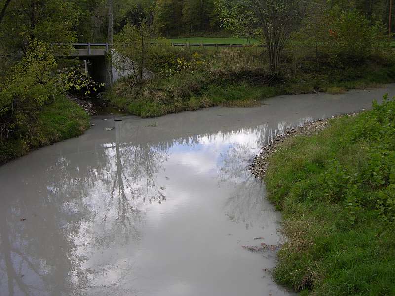
The milkiness in the water is due to high amounts of clay in the slurry
mixture.  It is not as harmful to wildlife as the darker gray solutes
in the slurry but does travel further downstream.  This photo was taken
Friday morning at the confluence of Piney Creek and Captina in
western Washington township.

Captina rebounding after two days of steady rainfall.  This photo is from
Tuesday morning and shows the water clearing.  Certainly not the
same as prior to the spill but in much better condition compared to
Friday in terms of overall water quality.


Tuesday, October 5, 2010

Captina Coal Slurry Spill 2010

On the morning of October 1st a pipe that transfers waste coal called "slurry" from the Century mine to OVCC #6 slurry impoundment pond ruptured allowing the substance to flow directly into the creek for a short period of time.  Mine officials were able to quickly contain the leak and efficiently clean the affected section of stream.  A map illustrating the contaminated area is shown below.

The effected zone, outlined in red, begins in eastern Wayne twp
and extends into western Washington twp. to the SR 148 bridge
crossing.
Now that the spill has been removed from the creekbed officials from ODNR and EPA can begin to assess the impact of the event on the creek's ecosystem.  Fortunately the creek has shown an incredible resilience to such events in the past and has been able to quickly rebound primarily due to the limestone bedrock that buffers the water against sharp changes in pH.